Thank you for your input on the transit study!
Based on screening criteria, public input, steering committee and stakeholder input, the Locally Preferred Alternative (LPA) recommended through this study is enhanced bus with a long-term transition to streetcar on Highland Drive. Beginning with enhanced bus allows streetscape and transit improvements to begin more quickly. These improvements could include transit signal priority, enhanced stations that begin to make room for expanded streetcar stations, and active transportation connections. Both transit solutions share a lane with vehicles, which greatly minimizes potential property impacts.

What comes next for Local Link?
The study team is working to present this recommended LPA and phasing approach to all four partnering city councils for input and approval. If the cities adopt the recommended LPA, the study team will work with Utah Transit Authority (UTA) and Wasatch Front Regional Council (WFRC) to incorporate it in their long-term transportation plans.
Enhanced bus can be implemented in the near future, as soon as funding can be secured in a few years.
In order to implement streetcar, funding must be allocated which could take five to 20 years before implementation. As funding becomes available, the next step would be to complete an environmental study that would further engage the community and evaluate impacts as well as identify potential mitigations. After that, the project would go into preliminary engineering and design prior to construction. To see a study process graphic, go here.
To see what the Local Link study team analyzed, scroll down.
POTENTIAL TRANSIT LOCATIONS
Each of the two routes, 1300 East and Highland Drive, connects Sugar House, Millcreek and Holladay, and is a vibrant part of these communities. A new transit solution on either route will improve the connection between the cities and provide more accessible and sustainable transportation options for all users in the future. Note that both potential alignments begin south of 2100 South on Highland Drive and split just south of 2700 South (see map).

WHAT DO THESE ROADS LOOK LIKE NOW?
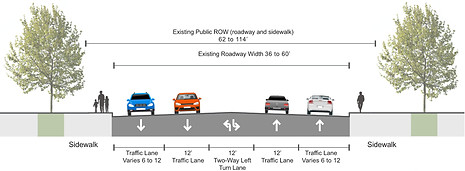
Both corridors are densely populated with a mix of commercial and residential properties. 1300 East currently has one travel lane in each direction, with a center turn lane and shoulders and sidewalks on each side. Highland Drive currently has two lanes of traffic in each direction, with a center turn lane and sidewalks on each side.
The partnering cities plan to continually develop each corridor over the coming years with Millcreek building a new city center and Holladay developing the old Cottonwood Mall site. Check out each city’s website for more information on these efforts (Millcreek and Holladay).
1300 EAST

HIGHLAND DRIVE

These graphics depict typical cross sections of 1300 East and Highland Drive. Some segments of each road may vary.

What transit options are possible?

Streetcar
Streetcars are rail transit vehicles designed for local transportation on a city street, and powered by overhead electricity. They share a lane with vehicles.
Light Rail
Light rail is a passenger train that requires its own tracks and a separation from vehicle traffic.


Bus Rapid Transit (BRT)
BRT is a bus-based transit system that includes a dedicated travel lane (separate from vehicles), traffic signal priority and enhanced stops or stations.
Enhanced Bus
Enhanced bus runs more frequently than the existing bus line with a limited number of stops. It is not separated from traffic.


HOW DO THESE TRANSIT OPTIONS COMPARE?
Here’s a look at how the 1300 East and Highland Drive options compare to one another in construction and long-term benefits.


HOW DO THESE OPTIONS IMPACT PROPERTY?
Most of these potential transit options would require more space than is already available along 1300 East and Highland Drive. The study team has estimated approximately how many properties would likely need to be purchased in order to implement each option*.


HOW MANY PEOPLE CAN EACH TRANSIT OPTION MOVE?
We wanted to see how many more people we could move with each transit option compared to adding a new lane for vehicles. We learned each transit option can move significantly more people than an individual car can, and would reduce traffic congestion and travel times in 2050.
HOW MANY PEOPLE PER DAY IN 2050 WOULD USE EACH TRANSIT OPTION?
Study projections show that in 2050 light rail would bring in the most riders on either 1300 East or Highland Drive, while Streetcar would serve the fewest on 1300 East and enhanced bus on Highland Drive.


HOW WOULD EACH OPTION AFFECT AIR QUALITY IN 2050?
Our partnering cities are committed to reduce local air pollution through transit, so as one part of that, the Local Link team has compared carbon emissions savings over 25 years for each option. With more individuals using these transit options in 2050, fewer cars would be on the road and individual vehicle emissions would be reduced. Reduced air pollution is one component in improving air quality in the Wasatch Front and addressing long-term climate change.

HOW MUCH WOULD EACH OPTION COST?
It’s important to each city that the selected transit solution is affordable, feasible to construct and works collectively for all of the cities.
The study team has gathered past project costs and future construction costs to come up with an estimated range for each transit option. These estimates take into account transit construction, road widening where needed, associated right-of-way costs and operation costs for each option.

HOW WOULD EACH OPTION CHANGE THE EXISTING ROAD?
These future cross sections, below, show that light rail and BRT would require their own dedicated lanes, while a streetcar would share a lane with traffic. Enhanced bus would not change the existing roads.
1300 EAST

Existing Road/Enhanced Bus
HIGHLAND DRIVE

Existing Road/Enhanced Bus


Light Rail
Light Rail


Streetcar
Streetcar


Bus Rapid Transit (BRT)
Bus Rapid Transit (BRT)
A final recommendation will be presented to the four partnering cities.
